
Raconteur/novelist Jack Kerouac proclaimed “the road is life” and here in Yosemite Mariposa County that credo joyfully echoes off granite walls. With every criss-crossing highway, every dramatic valley connected by undulating forest, there’s a breezy vibrancy distinctively blended with deep-rooted history. And nowhere is this rugged spirit on display more prominently than in the small-town charm of Yosemite Mariposa County.
Dotted with hidden gems, Mariposa County is best navigated by its distinct regions. We’ve put together a four-day itinerary to help visitors get the lay of the land as well as a local frame of mind. Whether exploring its fascinating past or relaxing in its rustic present, feel free to pick and choose or link “˜em all for one unforgettable journey.
Day One: Northern Mariposa County
Our Grand Tour of Tiny Places begins via Highway 132 as it climbs eastward into the historic reach of rolling foothills. Depending on the season, the iconic western landscape can be a misty green (winter) or hazy straw (summer) but its beauty is definitely year-round as the distant Sierra Nevada peaks come into view. Today’s exploration involves Northern Mariposa County “” a constellation of small towns where weekend brunch and Gold Rush ghosts are just a few of the welcome diversions.
Coulterville
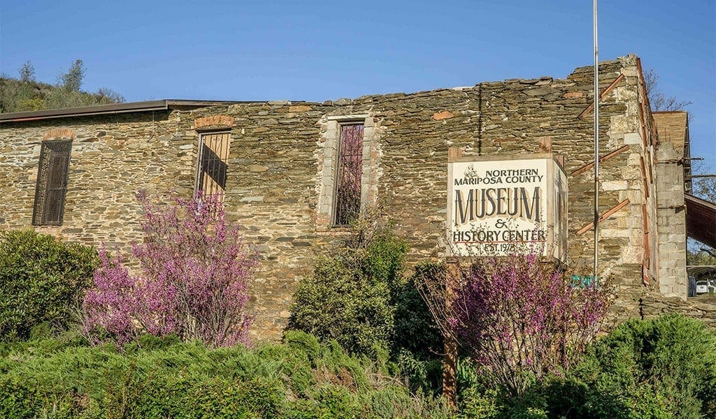
At the Junction of Highway 132 and Highway 49 sits Coulterville a laid back amalgam of old & new. With nearly as many California Historical Landmark buildings (40) as residents (60), here you can park your car and walk the Gold Rush historic charm of main street for a full-contact mining camp experience. Built in 1854, the reputedly haunted Hotel Jeffrey oozes Old West charm with its wooden balustrades covered in huge 100-year-old wisteria vines on the second floor balcony and once hosted the likes of John Muir and President Teddy Roosevelt. The Northern Mariposa County History Museum assays all the diggings in one place while the abandoned Sun Sun Wo Store offers a glimpse into the past as the last remnant of the Mother Lode’s largest Chinatown.
Hungry? Try the Coulter Cafe and General Store, a foodie oasis that also serves as supply stop where visitors can enjoy chicken & waffles for brunch or grab a bottle of local wine for that Mariposa County picnic. Need a place to stay? There are a number of unique sleeps in Mariposa County, including a decommissioned 1964 boxcar lovingly appointed as the Vacation Station and the Yosemite Gold Country Motel for rooms and even simple pre-set camping tents for rent.
Greeley Hill
Heading northeast from Coulterville, Highway 132 officially becomes the John Muir Highway as it climbs towards Greeley Hill. Offering impressive Central Valley and High Sierra vistas, Greeley Hill is the doorstep to the western edge of Stanislaus National Forest where visitors can hike & bike its vast network of fire roads, as well as enjoy fishing and dispersed (primitive) camping. There are a smattering of small businesses and friendly locals to chat about the weather & regions history.
Buck Meadows
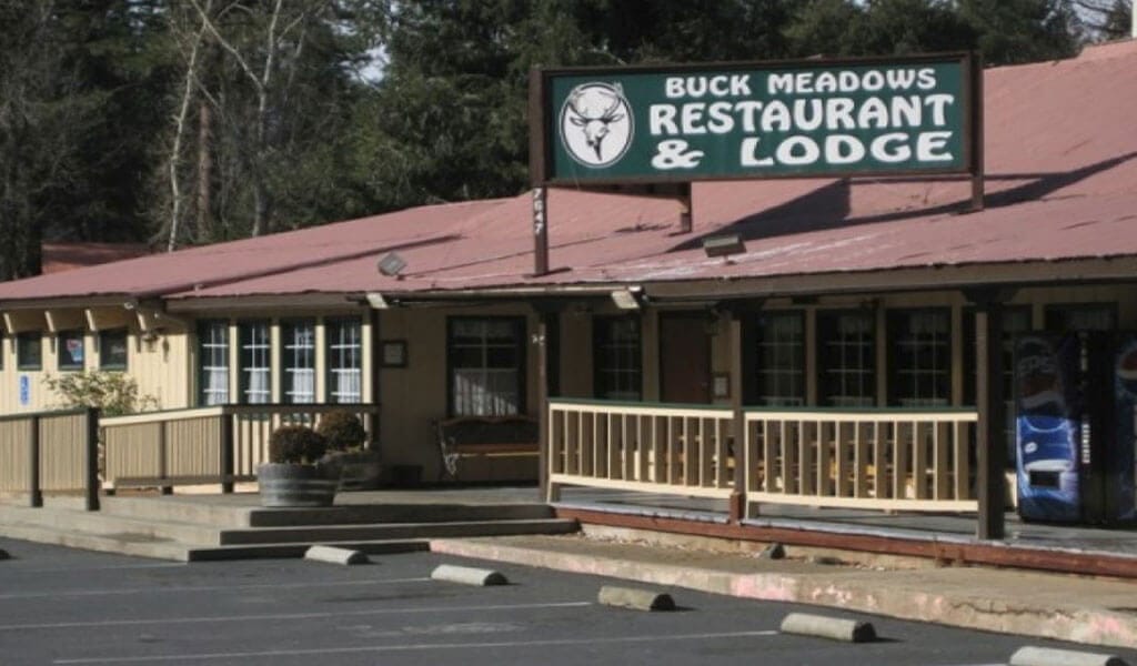
Continuing north along Highway 132 (Smith Station Road) for 8 miles brings you to the intersection for Highway 120 where a right (east) turn leads to the quaint enclave of Buck Meadows. Just 12 miles from the Big Oak Flat Entrance to Yosemite National Park, Buck Meadows is a great place to grab a bite of American comfort food at the Lucky Buck Cafe. Book a cozy cabin for the night at the budget-friendly Buck Meadows Lodge, or a spacious room next door at the Yosemite Westgate Lodge. Electric Vehicle (EV) drivers fret not the juice “” there’s a shared Electrify America charging station on-site.
Another outstanding lodging option is Blackberry Inn Yosemite. A stunning bed & breakfast that is a five-time recipient of the TripAdvisor Certificate of Excellence.
Day Two: Foresta & Central Mariposa County
Our second day of small town rambling focuses on the hidden, history-rich hamlet of Foresta and Central Mariposa County where the steep-walls of the Wild & Scenic Merced River canyon provide rugged drama. There’s one quirk on this day of travel “” you’ll enter Yosemite National Park at the Big Oak Flat Entrance and exit at the Arch Rock Entrance “” but your pass will allow unlimited entry to the Park for 7 days after purchase.
Foresta
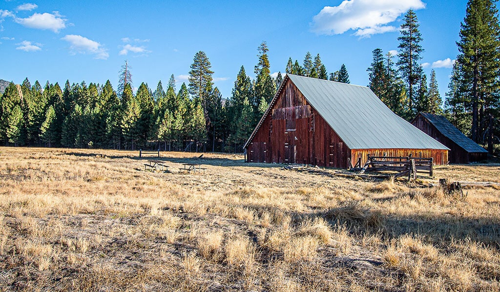
Located just under 30 miles from Buck Meadows (and 15 miles from the Big Oak Flat Entrance), the blink-and-you’ll-miss-it turnoff to Foresta means that few visitors explore this hidden meadow vista. Situated at 4,314 feet, Foresta has an interesting history and is one of only three areas of private property within the boundaries of Yosemite National Park. Worth seeing in Foresta are the McCauley & Meyer Barns (National Historic Landmarks) while hikers can check out the lightly-visited Foresta Falls “” an easy 2 mile out & back to a cascade along Crane Creek. There are no hotels in Foresta, but you can stay in a handful of vacation rentals, some with views of a surprisingly close Half Dome to the east. Note: This is private property so please be respectful of the residents and park clear of any driveways or roads.
El Portal
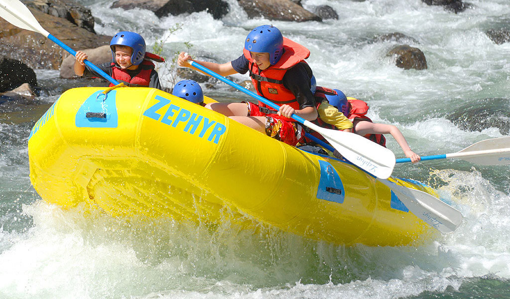
El Portal may only be a few miles down canyon from Foresta as the crow flies, but reaching it requires a 14-mile drive west along Highway 140 where the road doesn’t disappoint with austere beauty as it winds alongside the Merced River. In keeping with its name, El Portal is the gateway to Yosemite’s western entrance and features trout fishing, whitewater rafting (spring/early summer) and several day-use picnic areas where baskets are always welcome. Boasting the closest overnight accommodations outside of the Park’s gate, El Portal offers a range of options from hotels such as the Yosemite View Lodge and Yosemite Cedar Lodge, to camping at Dirt Flat and Dry Gulch Campgrounds, or living your best van life at Indian Flat RV Park. Also in El Portal are some of the last remnants of the Yosemite Valley Railroad, which used to be the main way for visitors to get into Yosemite. Still standing are a caboose, a turntable and the Bagby Station, which was deconstructed and moved upstream to El Portal when the Bagby Dam was built.
Briceburg
Located 16 miles west of El Portal, Briceburg is where the South and Main Forks of the Merced River. Though not technically a town, a small store was built here in 1926 during the construction of All-Season Highway 140 that catered to tourists and locals alike. The store has been transformed into the Briceburg Visitor Center where visitors can stop and learn more about the area’s fascinating past. In addition to fishing, hiking, swimming and rafting, there are three first come/first served Bureau of Land Management -operated campgrounds in Briceburg as part of the Merced River Recreation Area: McCabe Flat; Willow Placer; and Railroad Flat. Need to stretch your legs? Drive to the end of Briceburg Road and hike the Merced River Trail.
Midpines
A few miles uphill from Briceburg, Midpines sits at 2,585 feet and was founded in 1926 by Newell D. Chamberlain as a resort along the newly built Highway 140. There’s a mixture of pine & oak dotting the landscape with a smattering of homes tucked between.
Worth exploring here is the Yosemite Bug Mountain Resort. Situated in a small valley with a stream coursing through, the “Bug” as it’s affectionately known offers a variety of accommodations from hostel beds to cabins on stilts and several vacation rentals. The on-site Yosemite Health Spa is a great place to decompress after a long day on the trail with treatments like aromatic herbal baths and massage, while the daily-changing menu at the June Bug Cafe is known by locals as one of the best restaurants in the region, dedicated to healthy & tasty road eats including a solid selection of vegan and vegetarian options.
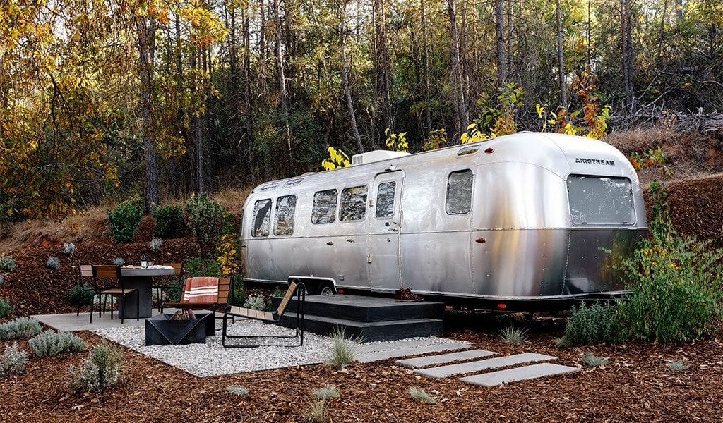
For another unique Mariposa stay, try the upscale glamping AutoCamp Yosemite with its armada of new iconic AirStream land yachts that have been carefully appointed for ultimate Sierra comfort, and enjoy ACY’s “Experiences” such as Say Om Beneath The Trees (yoga) and Live Music Happy Hour at the Clubhouse.
Day Three: Southern Mariposa County
Day three, and we’re rolling. As in rolling along the gentle slopes of Southern Mariposa County. This is some of America’s richest pastureland, dotted with stately oaks and the occasional mare and her foal seeking shade beneath those chivalrous branches. There may not be much “civilization” here, but we like it that way. Whether on bike or in a car, the cattle counties wide-open spaces provide a respite from our busy lives back home and plenty of room to explore the history-rich relics of the Mother Lode’s golden past.
Bear Valley
Located 17 miles from Midpines along Highway 49, Bear Valley was the hub of Colonel John C. Fremont’s mining empire after he purchased the 44,000 acre Mexican land grant Rancho Los Mariposas. The Gold Rush history runs deep and the original buildings from the mining days including the BonTon Saloon, Trabucco Store and Odd Fellows Hall are worth the stop. Look for the Bear Valley Historical Marker (California Historical Landmark No. 331) on Highway 49 for the local dish on this transformative period of California history.
Hornitos
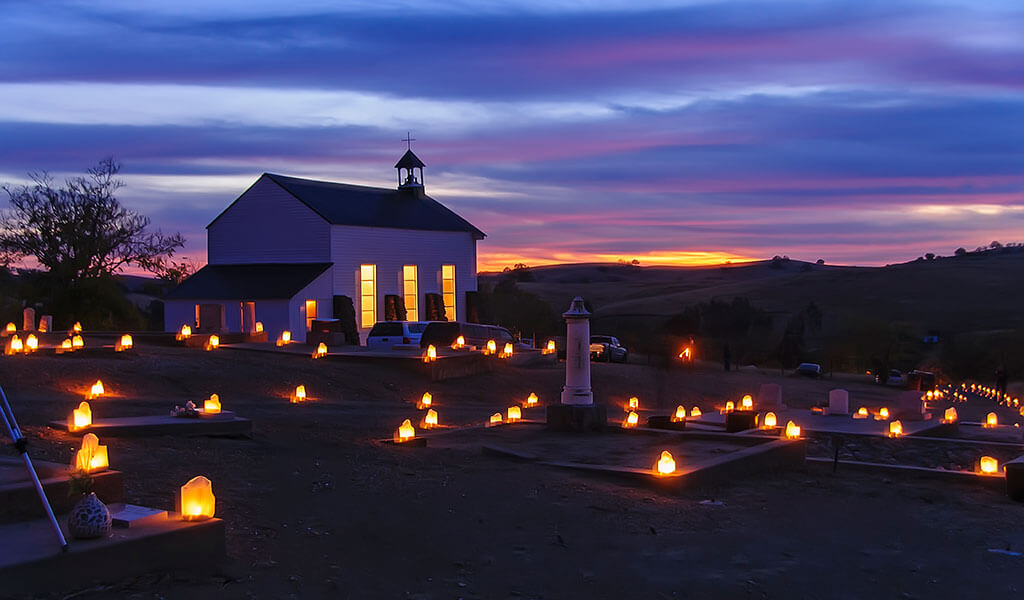
Following Bear Valley Road for 10 miles as it weaves through rocky cuts brings you to the equally fascinating Gold Rush “ghost town” of Hornitos. Home to the first Wells Fargo stagecoach office in the county, Hornitos (California Historical Landmark No. 333) has a current population of 66 but was once home to 15,000 people during in the 1870’s. Word on the street has it that bandit-hero Joaquin Murrieta built a tunnel from the Hornitos dance hall to his private horse stable to evade lawmen, all part of the high-spirited local lore. The remnants of this bustling time can now be found in the many architectural ruins that dot the landscape, including the crumbling walls of famed chocolatier Domenico Ghirardelli’s general store. Stop for a beer at the Plaza Bar or experience the yearly All Souls’ Day celebration a candlelit procession from St. Catherine’s Catholic Church to the cemetery in honor of the Day of the Dead (Dia de los Muertos). Also not to be missed is the annual community “Enchilada Festival” held on a weekend every March for over 70 years.
Catheys Valley
From Hornitos the two-lane road finds its way through the oaks as it eases past proudly framed barns and whitewashed horse corrals, sure signs of country living. After 12 miles “” at the intersection with Highway 140 “” you reach Catheys Valley. Situated at 1,325 feet, Catheys Valley originated as an agricultural and ranching community in the 1850’s. It was known by local miners for producing good fruit and grains, and even had its own newspaper “” The Cathey Cackler “” in the early 1900’s. You’ll find a clean well-kept family park with the original 1879 schoolhouse, accessible restrooms, playground and more. This is a great place to ride bikes (Hornitos Road/Old Toll Road/Mt. Gaines Road) and watch sunsets off to the west from this initial yet prominent rise of the Sierra foothills. Local eats include the Oasis Cafe where you can get everything from red & green chilaquiles to a double B.L.T. Lodging includes the Posada Mariana Bed & Breakfast, a 25-acre hacienda where each of its four rooms is named after a different town in Mexico and enters through a central courtyard. Other vacation rentals including farm stays are available for those who’d like to immerse themselves in Gold Rush gem.
Day Four: Fish Camp & Southern Yosemite
The fourth and final day of our small town expedition ends on a “high” note. The elevations of Fish Camp (5,062 ft) and Wawona (3,999 ft) in Southern Yosemite create a densely forested backdrop for unrivaled outdoor recreation. From hiking and swimming the South Fork of the Merced River to riding vintage trains and sledding in winter, this finale is a rowdy posse of plein-air diversions.
Fish Camp
Just two miles from Yosemite National Park’s South Gate, the historic Highway 41 hamlet of Fish Camp is indeed the hub of many old and new recreational activities. The Sierra National Forest historic access Jackson Road behind first class resort Tenaya Lodge at Yosemite offer ample biking options (rentals available) and the short drive or walk to Yosemite Trails Horseback Adventures, established in the 1930’s. Winter opens up the sled runs at Goat Meadow Snowplay Area and many family winter activities. Just down the tracks is Yosemite Mountain Sugar Pine Railroad, a memorable ride through the woods alongside the former logging flumes that once dropped into the central valley. And of course there is the Mariposa Grove of Giant Sequoias (Park entrance fee required) where guests can feel the strength of these titan trees whether on foot or via snowshoes. Hotels, locals market, attractions, camping and vacation rentals are available making Fish Camp a small town destination with big possibilities for fun.
Wawona
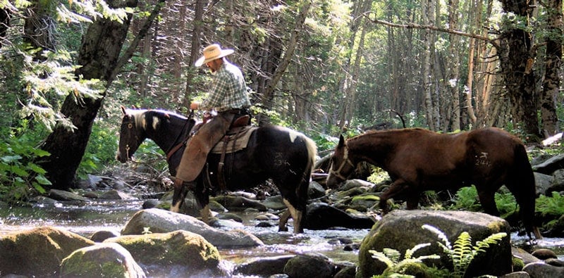
Located inside Yosemite National Park just seven miles from Fish Camp, the historic hub of Wawona offers visitors not a glimpse but a long stare into Yosemite history. Set at an elevation of 4,000 feet (the same as Yosemite Valley), the diversity of flora & fauna allowed the native Miwuk people to thrive here for millennia. The Buffalo Soldiers of Yosemite “” a little known but fascinating chapter of African-American history “” were instrumental in developing Wawona. In the 1870’s, Wawona became a waystation for the increasing number of tourists until the building of the Wawona Hotel in 1875. Now a rare National Landmark & treasure, hotel guests and campers alike can play 9 holes at the Wawona Golf Course “” one of the few organic courses in the country “” or take a lap around Wawona Meadow for spring wildflowers and to watch deer grazing on its forested edges. Fans of the days of yore are encouraged to buff some history at the Yosemite History Center, while hikers can shake it out on the less-visited but equally impressive Chilnualna Falls Trail and swimmers can make a long leisurely day of it with a picnic and a dip in the South Fork of the Merced River once the mercury rises. You will also find horseback riding to Chilnualna Falls, Wawona Visitor Center at Hill’s Studio, the Yosemite History Center/Museum, two full service markets and a gas station.
Good Things, Small Packages
There’s something to be said for taking the time to explore the little things in life. Hopefully these four, fun-filled days will help that cause, and our well-curated lists of where to stay, what to eat and the countless things to do will help travelers zoom in on the local level. As the great Californian author John Steinbeck wrote: “thus do the Gods speak with tiny causes.” Here in small town Yosemite Mariposa, the Gods just keep talking.
To explore lodging options, things to do and places to eat, visit Yosemite.com, the #1 trip planning site for vacations to Yosemite National Park and historic Mariposa County. To stay up to date, follow @YosemiteNation on social media and subscribe to our newsletter, “The Wanderer”. Be sure to subscribe to our YouTube channel for great videos on the people and places of Yosemite Mariposa County.
- October 08, 2025Explore Autumn: Leaf Peeping in Yosemite Mariposa CountyExperience the breathtaking beauty of autumn in Yosemite, where Yosemite fall colors light up the landscape. Explore scenic drives, leaf peeping trails, and golden meadows perfect for California leaf peeping adventures in one of the state's most iconic parks. Plan your trip today!Read More
- August 05, 2025Fall’s Last Call: How to Enjoy Yosemite’s Autumn MomentsSeasons come and go in Yosemite Mariposa County, each offering signature things to do and a variety of regions to discover. Autumn is one of the most distinctive seasons, warm and inviting in hue and humor before stormy winter weather rolls over the horizon.Read More

- July 06, 2025Only in Yosemite Mariposa County Can You…With authentic California history, monumental topography, and four-season outdoor recreation, Yosemite Mariposa County is one of a kind. This celebrated region of golden gateway towns flanking Yosemite National Park offers […]Read More

