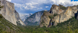
The benefits of hiking have been euphorically embraced from ancient times on. Hippocrates, the Greek physician, considered walking to be the best medicine. And here in Mariposa County, there’s plenty of that medicine to go around. Some of the best hikes in Yosemite don’t require exertion though easy Yosemite hikes often deliver great results. With soaring 13,000 foot peaks, historical oak-studded river valleys, and thundering waterfalls, Yosemite Mariposa offers what could be the widest variety of hikes in California. Whether it’s a slow amble through the wildflowers while the kids chase butterflies or a solo climb up the granite switchbacks as clouds pass beneath you, there’s a trail for everyone regardless of age or ability. The only constant? Fresh mountain air and the opportunity to get out of the car and stretch your legs, clear your mind and immerse yourself in nature. Here’s a collection of favorite local hikes, from sneaker-ready to double-knots required.
Easy Yosemite Hikes
Ideal for a quick break when time is tight or chatting with friends and family, these strolls feature gentle slopes, shorter distances and are perfect for incorporating into your kid-friendly Yosemite itinerary.
Tenaya Loop (formerly Right and Left Meadow Loop)

Distance: 1.3-mile loop
Elevation Gain: 246 feet
With the trailhead adjacent to the Tenaya Lodge, the Tenaya Loop is a peaceful stroll through the seasonal wildflowers of the Sierra National Forest while being serenaded by the babbling of nearby Big Creek. Perfect for all ages and abilities, the hike is dog-friendly (on leash) and has some benches if you want to stop and smell the lupine. One of the most laid-back and easy trails in Yosemite, you get to enjoy a beautiful yet easy Yosemite hike, as well as the ability to haul kids and dogs in the car with a parking lot nearby. After your journey, refuel with tasty pub fare right back where you started at Jackalopes Bar & Grill.
Diana Falls & Swimming Hole
Distance: 1.4-miles out & back
Elevation Gain: 85 feet
Located along Bean Creek near the historic town of Coulterville, Diana Falls is a relaxing jaunt to one of those old-fashioned swimming holes where memories are made. . One of many Mariposa hikes, this flat, dog-friendly trail passes through both wooded and open stretches in the Yosemite Valley, perfect for kids who want to take a dip in one of several pools along the way. Diana Falls is best in spring and early summer when flow is highest, but worth a picnic any ol’ time. Be sure to wear sticky-soled shoes for scrambling on the rocks, and if you still have energy afterward visit the nearby Northern Mariposa County History Center for local Gold Rush tales or Bower Cave, a limestone grotto the native Miwuk people called “Home of the Evening Star” and where stagecoach visitors back in the day held dances on Saturday nights! This is one of the easy Yosemite hikes that’s sure not to disappoint!
Sentinel Meadow/Cook’s Meadow Loop
Distance: 2.2 mile loop
Elevation Gain: 85 feet
In the heart of Yosemite Valley, this hike has it all: world-class views of Yosemite Falls and Half Dome; verdant, wildflower-dotted meadows in spring/early summer; wildlife at dusk and dawn. Crossing the Merced River twice at the Sentinel and Swinging Bridges, the path is gently accessible to kids, seniors, wheelchairs and strollers alike. Dogs are welcome (on leash, paved sections only) and for those hikers who don’t like to venture far from a bathroom there are several along the way.
Moderate Yosemite Hikes
The broadest category (meaning not all moderate hikes are created equal), these trails feature greater distances and more hills than their easy counterparts, with commensurate rewards.
Stockton Creek Preserve

Distance: 3.1 miles loop
Elevation Gain: 501 feet
Starting a few blocks from downtown Mariposa, the dog-friendly Stockton Creek Preserve trail winds through a classic California oak and chaparral setting up to Stockton Creek Reservoir. The 410-acre Preserve is a magnet for many bird species, the Oak Titmouse, Ruby-crowned Kinglet, Mountain Raven, Northern Flicker, Hooded Merganser, American Coot and Wood Duck among them. The lower loop trail features a graded fire road, while the upper loop provides expansive vistas overlooking the water and surrounding hills. In addition to the bird show, numerous amphibians and reptiles, including the Western Pond Turtle (the West Coast’s only native freshwater turtle) live here. After your hike, explore the charming Gold Rush town of Mariposa for food, museums and the oldest (1854) Superior County Courthouse still in use west of the Rockies.
Corlieu Falls & Red Rock Falls (Lewis Creek Trail)
Distance: 3.9 miles out & back
Elevation Gain: 531 feet
With its shady tree cover and fern grotto feel, the Lewis Creek Trail transports hikers to a mythical paradise. Located near Fish Camp, the journey is a two-for-one special when it comes to waterfalls. A few hundred feet from the turnout on Highway 41, the trail forks right (downstream) and drops .5 miles to Corlieu Falls. Named after the “Cliff Man” Clifford Corlieu, this multi-tiered waterfall drops 80 feet and the rock foundation of a cabin where the Corlieu lived from 1910 to 1929 can still be found. Going left (upstream) at the fork, the trail follows Lewis Creek where the remnants of a lumber flume can be seen. The flume was operated by the Sugar Pine Lumber Company from 1900 to 1931, plunging 54 miles to the Central Valley town of Madera. After arriving at Red Rock Falls, hikers will experience a wider, more powerful cascade of 20 feet. This outing is great for kids and dogs are welcome, but bring bug repellent and expect plenty of trail company on weekends, as this is one of the more popular Yosemite Mariposa hikes available.
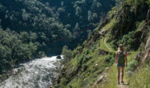
Merced River Trail

Distance: 5.5 miles out & back
Elevation Gain: 482 feet
Starting near the BLM-operated McCabe Flat Campground, the Merced River Trail follows the old Yosemite Valley Railroad line above and along the Wild & Scenic Merced River. The hike features spring wildflowers, swimming (there’s a beach at the campground, or you can scramble down in several spots for a refreshing dip) and the ever-present serenade of flowing water. At trail’s end there’s a narrow spur that climbs to a seasonal waterfall, worth the effort if still running. The Merced River Trail is dog-friendly (on leash) and great for kids, just remember to bring a hat and plenty of water as there is little cover.
Hite Cove Trail

Photo: Damian Riley
Distance: 9 miles out & back.
Elevation Gain: 980 feet
A popular destination in spring, this trail follows the steep Merced River canyon while passing by nearly 50 varieties of wildflowers. The first two miles display the greatest abundance, and the hike can be extended out-and-back to visit the abandoned Hite Mine. Historically significant to both native peoples and European-Americans, the Hite Cove area was used by the Ahwahneechee people in winter and spring to avoid the harsh high-elevation snow, before returning to Yosemite Valley in summer. John Hite settled here in 1862 where he operated a gold mine for the next 17 years. The mine produced a total value of 3 million in today’s dollars. The trail closes during periods of “High Fire Danger” and doesn’t provide much cover, so bring a hat and plenty of water. Camping is allowed at Hite Cove, but a campfire permit is required.
Strenuous Hikes
Even longer with demanding climbs, these trails generously reward those hikers who want a serious challenge.
Vernal and Nevada Falls Loop (via the Mist Trail)

Distance: 8.8 mile loop
Elevation Gain: 2,191 feet
The first section of this route “” the Mist Trail “” is Yosemite’s most popular hike and for good reason. A 600-step granite staircase ascends alongside 318-foot Vernal Falls as a cool mist swirls. The workout is for real, but the experience is truly one-of-a-kind. At the top of the falls is Emerald Pool (no swimming) then the trail continues climbing to the top of 594-foot Nevada Falls. From here “” the highest point of the hike at 6,000 feet “” you pick up the longer, slightly less steep John Muir Trail for an alternate way back down to the trailhead. The crowds tend to thin out on this loop providing stunning “above the falls” views of your recent achievement. This hike can be done in several configurations based on your fitness level: an easy/moderate paved trail to Vernal Fall Footbridge provides an excellent “starter” view (1.6 miles out and back/400 foot elevation gain); the epic Mist Trail to the top of Vernal Falls (2.4 miles out & back/1,000 foot elevation gain); the continuation on the Mist Trail to the top of Nevada Falls ( 5.4 miles out & back/2,000 foot elevation gain); and finally the strenuous Vernal and Nevada Falls Loop (8.8 mile loop/2,191 foot elevation gain). Bathrooms are available along the Mist Trail portion. No dogs are allowed on the trail.
(Note: Ice can make this trail difficult to navigate in winter)
Clouds Rest Trail (via Sunrise Lakes Trailhead)
Distance: 14.2 miles out & back
Elevation Gain: 1,775 feet
Visitors to Yosemite can’t help but be awestruck when looking up at the prominent knife of granite known as Clouds Rest. Standing behind Half Dome like a big brother, its narrow ridge at the summit and lengthy approach make this hike truly challenging yet wholly gratifying. The route begins along Tioga Road at the Sunrise Lakes Trailhead (8,150 feet) next to “Jewel of the High Country” Tenaya Lake. The first 1.5 miles of the hike are relatively flat but then the fun begins. A series of switchbacks climb 1,000 feet over the next mile giving way to a gentler climb over the next four-plus miles until reaching the summit of Clouds Rest (9,926 feet). Once there, pat yourself on the back and exalt in views of Half Dome and the dramatic Tenaya Canyon as it cascades down to Yosemite Valley. A note of caution: while truly one-of-a-kind, this hike is very long, at high altitude, and with a short, but narrow (approximately 10 feet wide) passage on the ridge. Make sure you have acclimated to the altitude, are in good shape, have all the proper food/gear and not afraid of heights!
(Note: This trail closes in winter)
Hiking essentials…
- plenty of water (avoid single-use water bottles if possible)
- map (some hikes have no cell service so print/download if possible)
- mosquito repellent
- comfortable, closed-toe shoes/boots
- layers/waterproof shell (for summer thunderstorms and the Mist Trail!)
- hat
- eco-friendly sun block
- towel for hikes with water features
- lunch/trail snacks
- camera
- July 16, 2026Tips to A Great Yosemite Summer VisitPlan your Yosemite summer getaway with tips on exploring Hetch Hetchy, Yosemite Valley, Tioga Road, and relaxing by the Merced River.Catch these must-know tips to make the most of your time in Yosemite.Read More
- July 14, 2026How to Watch the Perseid Meteor Shower in Yosemite Mariposa CountyWish upon a shooting star during the Perseid Meteor Shower in Yosemite Mariposa County. The dark night skies in this area create exceptional night-sky viewing. So, read up for more information on where to go and what to bring with you this year.Read More
- May 14, 2026100 Things To Do In Mariposa County | Outside YosemiteDiscover 100 things to do in Mariposa County beyond Yosemite National Park, from outdoor adventures and historic Gold Rush towns to local food, lakes, art, and hidden gems throughout the Sierra foothills.Read More