
Our picks for some of the hardest hikes in Yosemite Mariposa County you can do in a day.
Researching the best day hikes in California, we’ve all seen this description. Strenuous. Listed just beneath distance and under the auspices of trail difficulty, strenuous may set off alarm bells for those casual amblers wanting a quiet stroll with the kiddos but rings the dinner bell for adventure-seekers craving a heart-pumping challenge. Whether it’s waterfall-flanked scrambles, view-loaded marathons, or 360-degree granite ascents, there’s one common denominator “” climb, baby, climb! Here you go, Captain Strenuous: check out our picks for some of the best hikes in Yosemite Mariposa County for a challenging day on the trail, then get laced up and go for it.
Clouds Rest

Distance: 14.5 miles (23.3 km) round trip
Difficulty: Strenuous
Elevation Gain: 1,775 feet (541 meters)
Trailhead: Tenaya Lake
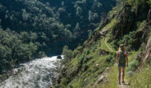
At the top of the toughest hikes in Yosemite list is Clouds Rest. With a unique view of Half Dome’s lofty backside, Clouds Rest is the flip-it-and-reverse-it alternative to jumping through hoops for a permit to climb the famed rock. Starting at the “Jewel of the High Country” Tenaya Lake, the trail begins gently enough but the challenge awaits. At the 1.5 mile mark, the switchbacks loom and rise 1,000 feet over the next mile “” your most grueling section of the hike. The trail then drops into a valley before the longer, steadier climb that brings you into the amazing home stretch. The payoff? A knife’s edge of granite that looks like an orca rising from the sea.
As hikers make their careful way along this rocky promontory, they will be rewarded with 360-degree views that include Tenaya Canyon on one side, Little Yosemite Valley on the other, and the aforementioned Half Dome directly ahead (and below!). The biggest considerations when undertaking Clouds Rest are time and water. Bring plenty of both!
Four Mile Trail & Panorama Trail Loop

Distance: 17 miles (22.5 km) round trip (14 if you shuttle between trailheads)
Difficulty: Strenuous
Elevation Gain: 3,200 feet (975 meters)
Trailheads: Four Mile Trailhead (enter)/Happy Isles Trailhead (exit).
Taken on its own, the Four Mile Trail is a beast rising 3,200 feet from the Valley floor to Glacier Point and its fabled views. Add to that a return via the Panorama Trail and you might have the hardest hike in Yosemite National Park! The climb begins in the shadow of Yosemite Valley’s Sentinel Rock along Southside Drive and follows the route of an historic toll trail originally built in 1872. About two-thirds of the way up is Union Point with its killer views, and a good spot to take a breather.
After reaching Glacier Point, hikers can either savor the snack concessions or shun the crowds that have driven up, but either way, the panorama of Yosemite’s greatest hits is undeniable. And since we’re not loafing around here, the return voyage heads 8.5 miles down the Panorama Trail which descends into the steep Ilillouette Gorge then rejoices in the rejuvenating mist of Nevada Fall and Vernal Fall. This is for hikers in top shape (healthy knees!) and requires careful planning (timing & supplies) to complete in a single day.
Mt. Dana

Distance: 6 miles (9.7 km) round trip
Difficulty: Strenuous
Elevation Gain: 3,100 feet (945 m)
Trailhead: Gaylor Lakes Trailhead or dirt parking lot just outside the East Entrance of Yosemite National Park.
Located near the East Entrance of Yosemite and rising 13,061 feet, Mt. Dana is the second highest peak in the Park yet is often overlooked due to its distance from the western gates. But one person’s oversight is another’s advantage, and for those adventurers wanting to bag a 13er (insider lingo for a 13,000-foot peak) Mt. Dana is officially the “road less traveled” hike in the list. The climb to the summit is steady-as-she-goes “” 1,000 feet per mile for 3 miles “” with much of the “trail” a scramble up rocky scree.
Mt. Dana offers beautiful views, some unlikely seasonal wildflowers, and is an excellent high-elevation warm-up for those preparing to climb Mt. Whitney (the tallest peak in the contiguous 48 States). No technical mountain climbing experience or ropes required, just the will to reach the top! The biggest consideration for Mt. Dana is elevation. Give yourself time to acclimate, and drink lots of water before, during and after the hike. If you feel symptoms of altitude sickness (headache, nausea, dizziness) head back downhill right away. While getting there along Tioga Pass (open seasonally after winter snow, typically May-November) stop and enjoy the golden splendor of Tuolumne Meadows.
Upper Yosemite Falls/Yosemite Point

Distance: 8.8 miles (14.2 km) round trip
Difficulty: Strenuous
Elevation Gain: 3,000 feet (914 m)
Trailhead: Camp 4/Upper Yosemite Falls Trailhead
A heart-pounding workout alongside North America’s tallest waterfall? You betcha. This switchback mecca climbs to the top of Yosemite Falls (2,425 feet) rewarding hikers with steps and views alike. Mile 1 brings you to Columbia Rock, a great place to stop (necessary after the 1,000-foot (305-m) climb!) and survey Yosemite Valley, not to mention the granite wonders of Half Dome and Sentinel Rock. Another .5 miles (0.8 km) brings you to the perfect vantage of what you’re about to undertake “” Upper Yosemite Falls.
After your mist-kissed photo op, it’s time to climb once again. The switchbacks are steep, rocky and 100% worth the effort. Once at the top, the views keep coming as demure Yosemite Creek disappears abruptly from the rim then goes through a personality change, plunging brazenly down to the Valley floor. For a nice encore, continue another .8 miles (1.3 km) east to Yosemite Point (follow signs for North Dome) to take an unobstructed gander at Half Dome, as well as have an intimate encounter with the Lost Arrow Spire. Check out the Yosemite Falls webcam to get an idea of how much water will be keeping you company!
Chilnualna Falls

Distance: 8.2 miles (13.2 km) round trip
Difficulty: Strenuous
Elevation Gain: 2,400 feet (732 meters)
Trailhead: Chilnualna Falls parking area (Wawona)
We’ll resist any puns about chilling at Chilnualna Falls, mainly because the climb is no laughing matter. One of the hardest hikes in Yosemite Mariposa County, it is located in the Wawona/Yosemite South section of Park, away from the sometimes maddening crowds of the Valley. The trail begins at an elevation of 4,200 feet (1280 m) and plays hide-and-seek with a series of falls, cascades and cataracts ranging from 50 to 240 feet (15 – 73 m) in height.
The climb is steady and steep for 4 miles (6.4 km) and the falls flow year-round (with peak runoff in May), making this the perfect hike for fans of consistency. After your adventure stop and have a “trail-cap” at the Wawona Hotel, or buff some history at the Pioneer Yosemite History Center.
Pro Tips
- Know your seasons and weather conditions. Some trails close fully or partially in winter and can be slippery when wet or icy.
- Know your sunrise and sunset times. These hikes push the limits of daylight so leave early and bring a headlamp in case that home stretch is in darkness.
- Never cut switchbacks for the safety of other hikers, and to minimize damage to the surrounding flora.
- Bring plenty of food & water. Pack a first-aid kit, including moleskin for blisters.
- Dress appropriately for high elevations. Comfortable hiking boots, plus warm layers that include a waterproof shell for waterfall mist and summer thunderstorms.
- Bring a paper topo map (and learn how to read it). Don’t rely on your phone as there is often no coverage in the backcountry.
- Check current road conditions as well as historical road/trail open (and close) dates.
- If you want to extend your day hike to include an overnight stay, Yosemite wilderness permits are required.
- Enjoy a Sierra Foodie tour of Yosemite Mariposa before/after your hike and check out our dining page.
- Explore our lodging page for a complete rundown of Yosemite Mariposa County accommodations.
Looking for more hiking ideas? Check out some of our favorite hikes outside of Yosemite, or get season-specific recommendations for our favorite Yosemite fall hikes.
- May 14, 2026100 Things To Do In Mariposa County | Outside YosemiteDiscover 100 things to do in Mariposa County beyond Yosemite National Park, from outdoor adventures and historic Gold Rush towns to local food, lakes, art, and hidden gems throughout the Sierra foothills.Read More
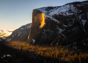
- January 21, 2026Yosemite Firefall 2026 GuideYosemite's natural firefall at Horsetail Fall draws hundreds of photographers for a few weeks in February when the setting sun lights Horsetail Fall and turns the water a brilliant molten orange, reminiscent of the Glacier Point firefall.Read More
- December 05, 2025How to Go Horseback Riding in Yosemite Mariposa CountySetting out for a horseback ride adventure from the Wawona Stable in Yosemite. Whether you’re a first-time rider or a seasoned equestrian, horseback adventures here offer an unforgettable way to connect with the landscape and explore Yosemite’s quieter, more peaceful corners.Read More


