Want to trek the best hikes at Tioga Pass and Tuolumne Meadows? This is a very short list of the almost endless trails in Yosemite’s renowned high country. The trailheads for each of these hikes are located off of Tioga Pass and each offer unsurpassed views of Yosemite’s vast wilderness areas and notable icons. Please be aware of the existing snow pack early in the season. If attempting a hike be prepared for flooding and snow on some trails.

May Lake and Mount Hoffmann
Distance: 2.5 miles (4 km) round trip to May Lake; 6 miles (9.6 km) round trip if you climb Mt. Hoffmann as well
Elevation at trailhead: 8,710 feet (2,655 meters)
May Lake Elevation: 9,270 feet (2,825 meters)
Mt. Hoffmann Elevation: 10,845 feet (3,305 meters)
Difficulty: Easy – May Lake, Mount Hoffmann – Strenuous
Time: 1.5 – 4 hours
For one of the easiest high country hikes with a big payload in terms of view you can’t do better than May Lake. This very easy 2.5 mile return hike to May Lake offers beautiful lake views without a lot of effort. However, if you are feeling like raising your heart rate continue on the trail upwards toward Mount Hoffmann. The geographical center of the park, Mount Hoffmann, is an unsurpassed hike for views looking down on Half Dome and Cloud’s Rest. Several switchbacks and big elevation gain mean that you should be prepared for this hike to be no walk in the park.

Learn more
North Dome
Distance: 8.8 miles (14.2 km) round trip
Elevation at trailhead: 8,100 feet (2,470 meters)
North Dome elevation: 7,540 feet (2,300 meters)
Time: 4 – 6 hours
Difficulty: Moderate
By far one of the best views of Half Dome, North Dome is a moderate hike that provides an epic face-to-face view with Yosemite’s most iconic dome. The first four miles are fairly uneventful but you should definitely take a short 0.6-mile detour to the Indian Rock Arch, a natural granite arch that is worth checking out on the way.
Pack a lunch so you can linger at the end of the trail admiring the beautiful view of Yosemite’s most famous icon.
Tip: This trail is very exposed with very little water available along the way for those with water filters. Be sure to wear a hat and bring plenty of sunscreen and water.

Cloud’s Rest
Distance: 14.5 miles (23.3 km) round trip
Trailhead Elevation: 8,150 feet (2,450 meters)
Clouds Rest Elevation: 9,926 feet (3,025 meters)
Elevation Gain: 1,775 feet (540 meters)
Difficulty: Strenuous
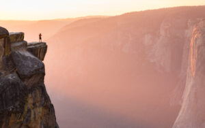
While difficult, the Cloud’s Rest Trail is a great alternative to those who want Half Dome views but not the punishing 17-mile trek that goes with getting to that summit, and one of our top five challenging hikes in Yosemite. Not to mention having to enter a lottery for permits several months in advance. Cloud’s Rest is located just above Half Dome and displays the same panoramic view of Tenaya Lake, Half Dome, Mt. Hoffman, Sentinel Dome, North Dome, and bits of Cathedral Rocks and El Capitan, and Merced Lake. The hike is topped off with a harrowing finish on a narrow ridgeline with sweeping valley views.
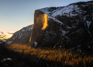
- January 21, 2026Yosemite Firefall 2026 GuideYosemite's natural firefall at Horsetail Fall draws hundreds of photographers for a few weeks in February when the setting sun lights Horsetail Fall and turns the water a brilliant molten orange, reminiscent of the Glacier Point firefall.Read More
- December 05, 2025How to Go Horseback Riding in Yosemite Mariposa CountySetting out for a horseback ride adventure from the Wawona Stable in Yosemite. Whether you’re a first-time rider or a seasoned equestrian, horseback adventures here offer an unforgettable way to connect with the landscape and explore Yosemite’s quieter, more peaceful corners.Read More

- October 08, 2025Extreme Adventures: Yosemite Adrenaline RushFrom granite walls to rushing rivers, Yosemite Mariposa County delivers four seasons of heart-pounding adventure for thrill seekers and outdoor lovers alike.Read More