The convocation of rock that graces Yosemite National Park never fails to inspire. Huge slabs of exposed granite soaking up the sun, cliff faces rising thousands of vertical feet and, of course, the top geologic influencer of them all “” Half Dome. Indeed, Yosemite domes are stuff of legend. John Muir considered them friends, writing, “all the rocks seemed talkative…I bathed in the bright river, sauntered over the meadows, conversed with the domes, and played with the pines.” Now that’s some Sierra hospitality!
While climbing the ever-popular Half Dome is a daunting mission (permits, cables, embarking hours before your first cup of coffee), there are equally view-worthy options that require much less effort. Here is our roundup of Yosemite Mariposa County’s other domes “” an essential guide for adventurous visitors who want to enjoy these gentle watchtowers of granite in a slightly more civilized fashion.
What’s With All The Domes?
While other national parks have their signature attractions “” think Yellowstone’s geysers and Arches well… arches “” here in Yosemite we have granite domes. The million-dollar question is: why? The answer, as it turns out, is nothing less dramatic than fire & ice.
Millions of years ago during the volcanic age, molten magma cooled in underground chambers forming interlocking dark crystals of biotite & hornblende, as well as light-colored crystals of feldspar and quartz. The result was an incredibly strong and multi-colored rock “” granite.
Tectonic activity then pushed these underground formations to the surface of the earth until 10,000 to 15,000 years ago when the glaciers of the last Ice Age started bullying their way through the peaks and river valleys of the Sierra Nevada. But the glaciers underestimated their opponent. The tough granite rebuffed their advances and the erosion was left to lesser rocks. The resulting cliffs and domes “” always mottled, sometimes smoothed “” became the stunning Yosemite landscape we see today.
Meet The Domes
From roadside scrambles to docent-led hikes on private land, there are a number of notable domes worth visiting in Yosemite Mariposa County. All you need is some grippy sneakers and the desire to see for miles and miles from the top of these geologic phenoms.
Turtleback Dome
Distance: 1.2 miles (1.9 km) round trip
Trailhead Elevation: 4,920 feet (1,500 meters)
Turtleback Dome Elevation: 5,280 feet (1,610 meters)
Elevation Gain: 360 feet (110 meters)
Parking: A small lot on the Turtleback Dome service road, and pullouts along Hwy 41.
Located along Wawona Road (Hwy 41) near the famous Tunnel View, Turtleback Dome offers magic hour views west across the Sierra foothills towards the Central Valley, and east to the nearby titans of Yosemite Valley such as El Capitan. It also has its own webcam operated by the National Park Service. Note: if you decide to visit this quiet dome, be extra careful where you put your feet. The delicate Yosemite bitterroot flower blooms in shallow gravelly patches that are easily disturbed by careless footsteps.
North Dome
Distance: 10.4 miles (16.7 km) round trip
Trailhead Elevation: 8,100 feet (2,470 meters)
North Dome elevation: 7,546 feet (meters)
Elevation Gain: 554 feet (169 meters) on the return
Parking: Porcupine Creek Trailhead
Located along Tioga Road (Hwy 120) in the Northern Yosemite region, North Dome places visitors face-to-face with Half Dome as Yosemite Valley rests 3,500 feet below. There’s serious trail distance involved here, and some ups-and-downs, but the payoff is worth the effort if you’re in good shape. Viewable from North Dome is another nearby, nearly impossible to reach neighbor, Basket Dome. We suggest enjoying the views of Basket Dome, but don’t set out to ascend it. The views are the same from North Dome anyways.
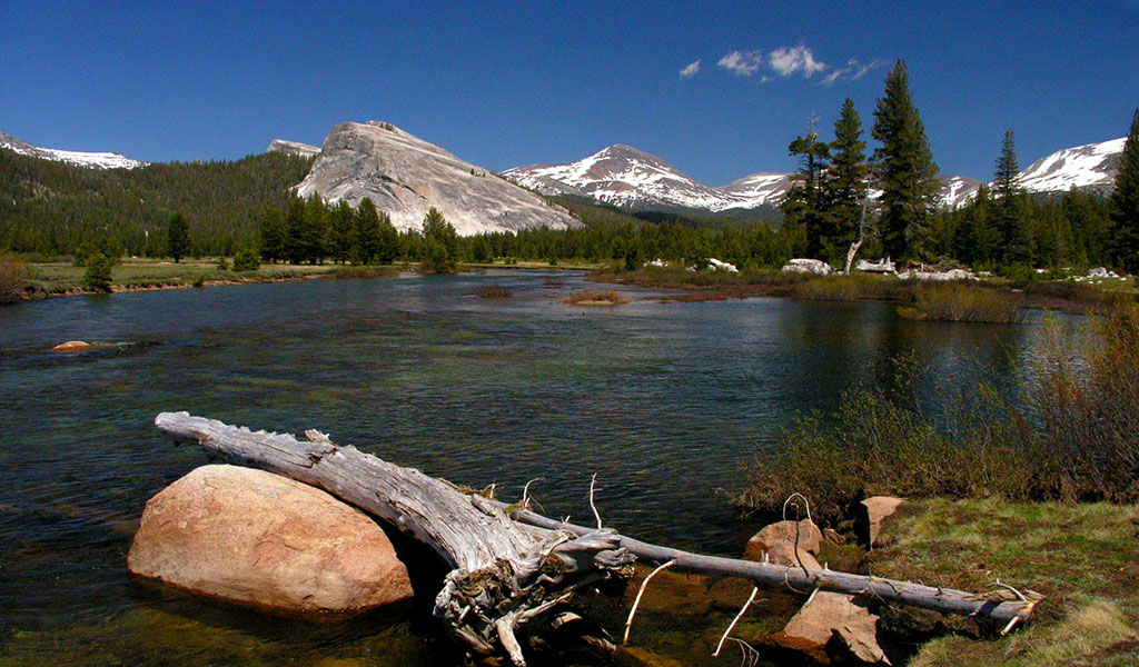
Pothole Dome
Distance: 2.5 miles (4 km) round trip
Trailhead Elevation: 8,500 feet (2,550 meters)
Pothole Dome Elevation: 8,760 feet (2,670 meters)
Elevation Gain: 260 feet (79 meters)
Parking: A small dirt parking area along Tioga Road directly adjacent to Pothole Dome.
Twelve miles east of North Dome along Tioga Road brings guests to a true roadside attraction “” Pothole Dome. Situated on the western edge of Tuolumne Meadows, this gentle bubble of granite can be approached from almost any direction. If it’s warm enough in summer, consider some Yosemite Mariposa County swimming with a dip in the Pothole Dome cascades along the meandering Tuolumne River.
Lembert Dome
Distance: 3.4 miles (5.5 km) out & back from Lembert Dome parking lot, 1.8 miles out & back from Dog Lake parking area, or 3.7 mile loop.
Trailhead Elevation: 8,600 feet (2,621 meters)
Lembert Dome Elevation: 9,455 feet (2,882 meters)
Elevation gain: 855 feet (261 meters)
Parking: Lembert Dome parking area or Dog Lake Trailhead (Shuttle Stop #2 near Tuolumne Meadows Lodge).
Another 14 miles east on our dome-hop brings rock hounds to Lembert Dome, yet another beaut right along Tioga Road. Looking like a granite wave rising from the pine forest, the long & steady approach makes this a great options for those who want a gentle climb where they can gaze across Tuolumne Meadows and marvel at Yosemite’s high country majesty. Bonus points for a choice of three routes!
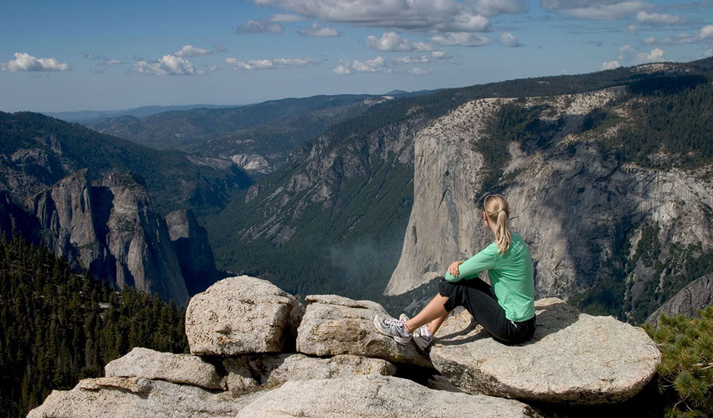
Sentinel Dome
Distance: 2.2 miles (3.5 km) round trip
Trailhead Elevation: 7,720 feet (2,353 meters)
Sentinel Dome Elevation: 8,122 feet (2,476 meters)
Elevation Gain: 402 feet (123 meters)
Parking: Sentinel Dome/Taft Point trailhead on Glacier Point Road. (For 2022 with Glacier Point Road closed, set out from the four-mile trailhead at the Valley Floor and follow the signs to Sentinel Dome once at Glacier Point)
Perched above Yosemite Valley’s south rim with dramatic 360-degree views of everything from Yosemite Falls to Half Dome and Yosemite’s tallest peaks in the distance, Sentinel Dome is a fan favorite for dome lovers worldwide. This popular destination in Yosemite’s Glacier Point region can be hiked out & back, or part of a loop to another rim-side vista, Taft Point.
Fresno Dome
Distance: 1.6 miles (2.6 km) round trip
Trailhead Elevation: 7,260 feet (2,213 meters)
Fresno Dome Elevation: 7,544 feet (2,299 meters)
Elevation Gain: 284 feet (87 meters)
Parking: A small dirt lot at trailhead, or pullouts along forest road.
Located just outside of Yosemite in the Sierra National Forest, this dome is reached via dirt forest roads resulting in a more intimate dome experience. The native Mono people called Fresno Dome “wah-me-yelo” which means “the greeting place,” and John Muir first spotted the Fresno Grove of giant sequoias (now called Nelder Grove) from its peak. A great base camp for Fresno Dome is historic Fish Camp, home of the world class resort Tenaya Lodge at Yosemite where domers can enjoy comfy accommodations, tasty food and luxe spa services.
To reach the trailhead, turn onto Sky Ranch Road (Road 632) on Highway 41 north of Oakhurst. This road eventually becomes Forest Road 6S10 to Kelty Meadow, which is unpaved and 4×4 vehicles are recommended. Follow signs for Fresno Dome Campground, stay on Road 6S10 past the junction for 2.8 miles and look for the turnoff for the Fresno Dome Trailhead.
Striped Rock
Distance: 4.5 miles (7.2 km) round trip
Trailhead Elevation: 1,720 feet (524 meters)
Striped Rock Elevation: 2,160 feet (658 meters)
Elevation Gain: 440 feet (134 meters)
Parking: Pullout along Ben Hur Road.
Ten miles outside the town of Mariposa, this interesting dome is situated on the private Striped Rock Conservation Preserve and can only be accessed through the Sierra Foothill Conservancy. The docent-lead hike (typically held on Earth Day in April) weaves through oak groves and spring wildflowers to a multi-colored rock outcropping with views of the High Sierra to the east, Striped Rock Creek valley to the south and Lookout Mountain to the west. While enjoying Yosemite Mariposa County please follow our Nature Rules! and never enter private property without permission. Note: contact the Sierra Foothill Conservancy for dates & details.
Take Nothing For Granite: Pro Dome Tips
- When climbing domes safety is of the utmost importance: always wear grippy shoes, bring plenty of drinking water and check the weather. Never summit when there is the possibility of lightning.
- For domes along Tioga Pass/Tuolumne Meadows, note that Tioga Road closes in winter so check current road conditions.
- Many of the domes have limited parking so consider taking YARTS and enjoy the views while somebody else drives!
- For a true dome-hopping experience, relax and spend a few days in Yosemite Mariposa County with its range of comfortable accommodations for every budget.
To explore lodging options, things to do and places to eat, visit Yosemite.com, the #1 trip planning site for vacations to Yosemite National Park and historic Mariposa County. To stay up to date, follow @YosemiteNation on social media and subscribe to our newsletter, “The Wanderer”. Be sure to subscribe to our YouTube channel for great videos on the people and places of Yosemite Mariposa County.
- May 14, 2026100 Things To Do In Mariposa County | Outside YosemiteDiscover 100 things to do in Mariposa County beyond Yosemite National Park, from outdoor adventures and historic Gold Rush towns to local food, lakes, art, and hidden gems throughout the Sierra foothills.Read More
- May 13, 2026What’s New in Yosemite Mariposa County This YearYosemite Mariposa County is buzzing in 2026 with new adventures and milestone celebrations. From YExplore Yosemite Adventures’ 20th anniversary hikes to Yosemite Boulder Farm’s new lodging and 1850 Distillery’s first sips, there’s plenty to explore. Photo feature of John DeGrazio with YExplore Yosemite Adventures, celebrating two decades of unforgettable Yosemite experiences.Read More
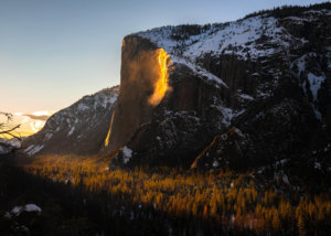
- January 21, 2026Yosemite Firefall 2026 GuideYosemite's natural firefall at Horsetail Fall draws hundreds of photographers for a few weeks in February when the setting sun lights Horsetail Fall and turns the water a brilliant molten orange, reminiscent of the Glacier Point firefall.Read More