Famed naturalist John Muir is probably best known for his roles in the creation of Yosemite National Park and the Sierra Club. A self-taught mountaineer and botanist, his enthusiastic love of nature carried him around the world on his own two feet. His favorite place on Earth, however, was always Yosemite.

Muir took a number of trips between the San Francisco Bay Area and what is today Yosemite National Park. His home, orchards, and gravesite are located in Martinez, but his first “ramble” started as soon as he got off a sailing ship from New York in April of 1868. He stopped a carpenter in the streets of San Francisco and said he wanted to go “anywhere that is wild.” The bewildered man directed him to take the ferry over to Oakland. From there, he walked south, through San Jose, then headed east toward the mountains.
In 2006, Peter and Donna Thomas were the first to reconstruct Muir’s route from Oakland, and walk it on foot, based on Muir’s writings and an amazing amount of other research. Their book, “Muir Ramble Route” is the definitive guide to this walking (and biking) tour with detailed mile markers and points of interest.
If you’d rather drive, however, begin your modern “ramble” in Gilroy. Muir asked for directions here on where to turn east toward Yosemite, and the answer was Pacheco Pass, which is now Highway 152. It’s highly recommended that you travel in April to see the green hills and wildflowers for the maximum Muir experience, but you can make your John Muir Yosemite journey any time of year.
Muir lovingly recorded his Yosemite trips in books, journals, and notes, and his own words speak best about what he experienced along the way:


Gilroy to Coulterville
The path through Pacheco Pass is now a busy highway and not a quiet dirt track, but it still winds through the same mountains.
As you leave Gilroy, you’ll see a number of old barns and houses that date back to Muir’s era, and it’s fun to imagine that he might have seen them too. Casa de Fruta is an historic stopping spot that dates from 1908. Originally just a roadside orchard and fruit stand, it’s grown to include a restaurant, children’s playground with train, petting zoo, RV camping, gas station, wine shop, and more, all with a “Casa de” theme. It’s a good place to visit “Casa de Restrooms,” for example.
The portion of Highway 152 between the Merced county line and Interstate Highway 5 is designated a California Scenic Highway, and you’ll discover a number of vista points with parking as you descend into the Central Valley. Before you reach Interstate Highway 5, however, you’ll take the exit for Highway 33 North toward Gustine. Continue north to the town of Newman, then turn right onto Merced Street, which becomes Hills Ferry Road.
Stay on Hills Ferry Road as you pass over the river where Muir once did. At the next fork, turn right onto River Road, following the sign for Livingston. Livingston is a good place to cross over Highway 99, and you’ll soon encounter McConnell State Recreation area on your way toward Cressey. In this area the roads skirt around farmland and rivers, so there’s no direct way to your next Muir waypoint, and intersections can be a bit odd. Watch your maps and GPS carefully for your best route due east to Oakdale Road, which then connects to county road J59 north, the Snelling Highway.
John Muir enjoyed this area and would sometimes stay in the nearby town of Hopeton (now just a couple of buildings) during his travels. As you cross over the Merced River on your way to Snelling, imagine him launching a little boat from near that spot and drifting blissfully downstream on his way back down to the flower-filled Central Valley.

Snelling is an interesting little historic town that also features a large gas station, markets, and post office. Take special note of the original (and tiny!) county courthouse building, which is California Historic Landmark #409, built in 1857.
From Snelling head east on Merced Falls Road toward Coulterville, making a very sharp left at Merced Falls. Merced Falls may be little more than some stone foundations buried in the weeds now, but it was an important stop for the Yosemite Valley Railroad and, being on the Merced River, featured a number of mills that required water to operate them. It’s hard to believe it was an industrial hub from the 1850’s to the 1890’s that John Muir would have seen as he passed through the area.Merced Falls Road ends at Highway 132 in Don Pedro. Turn right up 132, which has been designated the “John Muir Historic Route” in his honor, and toward the historic town of Coulterville. There are many recreational and camping areas along this stretch of your “ramble” in case you want to camp for the night in the method of Muir, such as the well-appointed Horseshoe Bend Recreation Area.
Merced Falls Road ends at Highway 132 in Don Pedro. Turn right up 132, which has been designated the “John Muir Historic Route” in his honor, and toward the historic town of Coulterville. There are many recreational and camping areas along this stretch of your “ramble” in case you want to camp for the night in the method of Muir, such as the well-appointed Horseshoe Bend Recreation Area.


Once you’ve arrived in Coulterville you’ll find a number of different small shops, a post office, and the Coulter Cafe, one of the main town hot spots. It serves a variety of fare from burgers to vegan dishes. In the summer they have music on their outdoor dining patio which is pet-friendly, and they sometimes host guest chefs for even more interesting specials of the day.

Coulterville has some charming lodging options to choose from. The Vacation Station features real train cars that have been transformed into adorable cottages, located right next to the Northern Mariposa County History Center on Highway 49. If you’d rather be outside of town, check out the vistas at Penon Blanco Lookout B & B just a quick drive up the road. Other choices include the Yosemite Gold Country Lodge, which is walking distance from town, and the Yosemite Coulterville Inn which is actually a few miles up the John Muir Historic Route (now Mariposa County Road J132) in Greeley Hill.


Coulterville to Tioga or Curry Village
Breathe in the fresh morning air of the foothills as you embark on the second part of your John Muir “ramble” toward Yosemite National Park. In Greeley Hill, named for Horace Greeley of “Go west, young man” fame, there’s a gas station and mini-mart, which is also the local hardware store, as well as a laundromat and an eatery or two depending on the time of day.
After you pass through Greeley Hill, you have a choice to make: The easy road, or the road less traveled. Naturally, John Muir’s original route takes the road less traveled, which includes a stretch of unpaved road just to the west of Pilot Ridge. If you choose the easy route, which is more suitable for average passenger cars, simply continue north on J132 (also called Smith Station Road here), keeping left at the fork and following the signs toward Yosemite until you reach Highway 120, then turn right (east) toward Buck Meadows.
To follow Muir’s ramble more closely, keep right at the fork and stay on Greeley Hill Road, which descends down toward Bower Cave and becomes Briceburg Road as you near the river. This route is only recommended for four-wheel-drive vehicles.

Bower Cave was a hive of activity in Muir’s day, where the locals built a series of ladders and stairs that descended to wooden platforms, including a huge dance floor where parties were held. It is also one of the most important sites for the local native Miwuk tribe. Legend says that all of creation issued forth from this cave, and out of respect for the tribe it is no longer open to the public. The historic marker for the cave and the original Yosemite-Coulterville stage road is just past the one-lane bridge, about four miles from where Greeley Hill Road forked from J132.
Past this point the historic stage road can no longer take visitors to Yosemite, so you will need to turn around and go a short distance back to Buck Meadows Road, where you’ll turn right. It’s paved for about a mile, but then the pavement ends, and you’ll be traveling on a semi-maintained dirt Stanislaus National Forest Service road that can have deep ruts and be muddy in wet weather. The adventure is worth it, however, with Pilot Ridge nearby just to the east of this road.

After a few miles, you’ll find yourself coming out of the wilderness and into Buck Meadows on Highway 120. The Lucky Buck Restaurant is a great place to refuel with a hearty meal, and you can also refuel your vehicle if need be at the nearby gas station. Buck Meadows does have lodging, including the Buck Meadows Lodge, Yosemite Westgate Lodge, and the Blackberry Inn, but for this trip you’ll be continuing east on Highway 120 and enter Yosemite National Park after about 12 miles.
At the Big Oak Flat gate there are some great “selfie” opportunities and a visitor information center. The rangers offer free maps and activity guides at the entrance kiosks, so be sure to take advantage of these if you don’t have a paper map already as cell service can be spotty due to the mountainous terrain.
Once inside the park, it’s about 15 minutes to Crane Flat, where the Tioga Pass Road heads off left toward Tuolumne Meadows and the east side of the park. Crane Flat has the only gas station on the north side of the park, and there is no gas inside Yosemite Valley. The market also has snacks and souvenirs.

Winter comes early and stays late at Crane Flat, and Tioga Pass is the highest highway pass through the Sierra Nevada mountains at almost 10,000 feet. It is closed for several months in winter due to snow so deep that it cannot be plowed, but when it’s open, the rewards are incredible. Be sure to check road and weather conditions in advance of your journey, and turn onto Tioga Road if you can.
One of the prettiest gems of the Tioga Road is Tenaya Lake, an especially nice place for a picnic after you explore the area.

Besides the market at Crane Flat where you can pick up some picnic goodies, there are three dining and food options along the Tioga Road where you can get a take-away or sit-down meal. White Wolf Lodge is the first one you’ll encounter after Crane Flat, serving a buffet-style breakfast and lunch. At Tuolumne Meadows you’ll find the Tuolumne Meadows Grill, with simple breakfast and lunch options like burgers and chili, or enjoy a family-style dinner at Tuolumne Meadows Lodge. All are open seasonally in summer only.
Muir camped all along this high plateau region, filled with hiking trails for all fitness levels and points of interest, such as Soda Springs. Part of the John Muir Trail rambles through this area as well. There are several campgrounds modern visitors can stay in today that he recorded in his journals, including Tamarack Flat, White Wolf, Yosemite Creek, Porcupine Flat, and Tuolumne Meadows.

If Tioga Road or Crane Flat are not open during your trip, the Hodgdon Meadow campground just inside the Big Oak Flat park entrance is open year-round. If you do arrive in winter, Crane Flat Campground doubles as a snow play area a safe distance away from the busy road into Yosemite Valley.
Lodging in the valley can be easier to obtain outside of the summer season. A good choice, and one contemporary to John Muir’s time in Yosemite, is Camp Curry, also known as Curry Village. This historic site has served visitors since 1899 and features a number of vintage structures including the 1904 reception building and world-famous “Camp Curry” illuminated sign built in 1914 (also a great photo op).
If you do choose to stay in the valley, you may be able to catch one of the wonderful John Muir one-man shows performed by Lee Stetson at the Yosemite Valley Visitor Center Theater. Stetson has been portraying Muir on stage and screen since 1983, including the Ken Burns documentary about Yosemite, and his shows bring the warmth and humor of Muir to life. Witnessing one of these evening performances would be a perfect way to wrap up the second day of your own Muir ramble.


Tioga or Curry to Wawona
A hot drink and a hot breakfast somehow taste better in the cool, clean mountain air. Whether you’re simply grabbing some coffee at Crane Flat on your way into the valley, or you’re having a sit-down breakfast in the Curry Village dining hall, savor the scenery as the sun rises over the trees and mountains that made Muir’s heart sing.

A good way to get your blood flowing is a morning hike from the Happy Isles trailhead at the east end of the valley. You’ll need to take one of the free shuttles to get there, which also means it’s one of the quieter areas of the park for a more peaceful experience. One end of the John Muir Trail can be found here, so you can walk a short distance on this 211-mile path through the mountains, which actually curves around behind Half Dome and climbs up into Tuolumne Meadows before turning south toward Sequoia National Park.
An easy hike combines the John Muir Trail with the Mist Trail which takes you to the lovely views of Vernal Fall, a popular subject for artists. If you’re feeling more fit and adventurous, you can take a bit more of the John Muir Trail where it splits off from the Mist Trail, then the trails converge again near the top of Nevada Fall. Don’t forget to take plenty of water and sunblock with you on these exposed granite wilderness trails with spectacular vistas in every direction.

When you get back to the valley, reserve plenty of time to see all the exhibits at the Yosemite Valley Visitor Center and the adjacent Yosemite Museum. There is a wealth of information about John Muir as well as the native people who came before, and the conservation efforts that have come after. There’s even a life-size bronze sculpture of John Muir that you can take photos with! The museum houses several of Muir’s possessions, including his tin cup that accompanied him on countless journeys around California.
The Yosemite Conservation Heritage Center (formerly the LeConte Memorial Lodge), on Southside Drive, is of special interest as well. This beautiful stone building was crafted in 1903 by the Sierra Club, which John Muir was president of at the time. Today it serves as a library and archive, and hosts the “Muir Ramble Route” logbook where you can record your own trip in the footsteps of this conservation giant.

After a hearty lunch at one of the many valley eateries, it’s time to head up into the mountains once again, this time toward the south. Head for the west end of the valley where all the highways meet, and take Highway 41 toward Glacier Point.
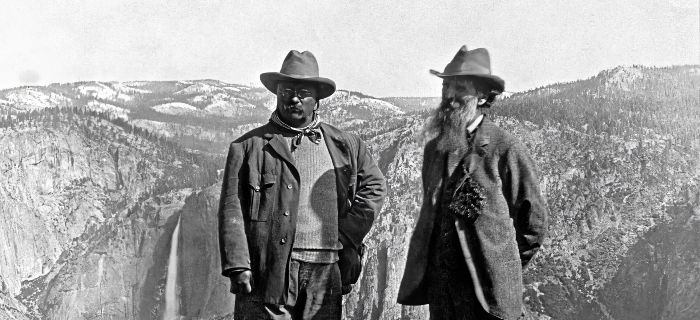
One of the most well-known photographs of John Muir is the one taken atop Glacier Point with President Theodore Roosevelt in 1903. While it’s not possible to stand in the same spot due to safety concerns (and please never climb over fences in the park!) you can see the same breathtaking views of the high Sierra Nevada watershed that Muir showed to Roosevelt on that trip, convincing him to expand Yosemite National Park into what it is today.

If Glacier Point Road is not open during your visit, or you don’t wish to do any winter snowshoeing on the many trails in the area, continue south to Wawona, which means “a good place to stop” in the local Native American language.
In the hushed and peaceful Mariposa Grove, you can walk through the same trees that Muir and Clark loved so much. Head south on Highway 41 to the Mariposa Grove Welcome Plaza for parking, tour information, water, and restrooms, then take the free (wheelchair-accessible) shuttle to the trail head. Once at the grove, you can choose between easy, medium, and strenuous trails through the trees. If you’re ready for even more adventure, try the 14-mile round trip hike from the Wawona Hotel to the grove and back again.

The grand Wawona Hotel was built in 1876, a bit after Muir’s first visit to the area, but contemporary to his many other visits over the years. The dining room serves breakfast, lunch, and dinner to hungry travelers from all over the world. If you’re unable to book one of the rooms inside the hotel itself, there is a nearby area called “North Wawona” that has a number of privately-owned vacation rental houses like The Redwoods In Yosemite.
Other amenities in Wawona include one of the only golf courses inside a national park, a swimming tank, horseback riding, and piano performances of vintage songs about Yosemite, courtesy of music historian and entertainer Tom Bopp at the Wawona Hotel.
Put up your feet and enjoy a quiet evening in a cabin, vacation house, or at the Wawona Hotel for a relaxing finish to your John Muir Yosemite journey. You’ve earned it!

If You Have More Time
There are a couple of other points of interest near this journey’s path that you may wish to add to your itinerary, now or in future visits to the area:
Pilot Peak has a historic fire lookout tower that may be accessed by the public in good weather via dirt roads. For more information on how to get there, visit the Stanislaus National Forest Groveland Ranger District office on Highway 120 between Buck Meadows and the Smith Station Road/J132 turnoff. The ranger station also has a wealth of books, maps, and nature displays for the family to explore.
If you decide to visit Muir’s estate and final resting place in Martinez, a trip up to the summit of nearby Mount Diablo in Contra Costa County is well worth the detour. You can stand on the tip of the rocky peak for a selfie while safely enclosed within this state park’s visitor center and museum. Muir spent the night on this landmark mountain in 1877, and you can experience some of the same incredible sweeping vistas of northern California that he recorded so lovingly in his journals.