Winter in Yosemite National Park is one of the most spectacular times of the year. Snow covers the peaks, the campgrounds and trails are less crowded, and there is no shortage of Yosemite winter hikes to explore. Learn more about the best winter hikes Yosemite has to offer, plus lower elevation trails near the park that stay open throughout the winter.
Winter Hiking: Yosemite National Park

The Best Winter Hikes in Yosemite Valley
Most visitors are surprised to find out that Yosemite Valley sits at only 3,966 feet. While it can get snow during heavy storms, the Valley is hikeable on the whole with warm boots, insulating layers and a desire to get up close and personal with the sheer granite. Plus, the flat terrain makes it navigable for all ages and fitness levels. What better way to go nose-to-nose with El Cap?
Yosemite Valley Loop Trail

- Distance: Up to you, but 11.5 miles for the full loop
- Elevations gain: Mostly flat
- Max elevation: 4,000 feet
- Difficulty: Easy to Moderate
Following many of the Valley’s original east-west trails and wagon roads, this choose-your-own-adventure allows the ultimate freedom to explore all of Yosemite’s glory. The Valley Loop Trail passes by “” or offers striking views of the Park’s iconic landmarks, from El Capitan to Yosemite Falls and Half Dome. Whether it’s a few hundred yards or the whole circuit, guests can park at any number of trailheads or turnouts to access this towering playlist of Mother Nature’s deepest cuts – a perfect option for a kid-friendly Yosemite itinerary.
Mirror Lake Trail
- Distance: 2 miles out & back
- Elevation gain: 100 feet
- Max elevation: 4,100 feet
- Difficulty: easy
This small, but visually compelling “lake” is more of a respite for Tenaya Creek as it flows into Yosemite Valley. Aptly-named, Mirror Lake offers wonderful reflections of Half Dome’s crown on its brooding surface, and winter adds a frosty frame to the masterpiece. Exhibits along this paved trail detail the story of the area’s lake-to-meadow succession as well as its cultural history. Though flat, it’s better to follow the out & back trail on the north side as ice and snow often cover the loop route to the south. Bring your camera!
Vernal & Nevada Falls (Winter Route)

- Distance: 2 miles out & back (to footbridge); 5.4 miles out & back (top of Vernal Fall)
- Elevation gain: 400 feet (footbridge); 1,500 feet (Vernal Fall)
- Max elevation: 5,000 feet
- Difficulty: easy-strenuous
One of the most popular and challenging hikes in Yosemite is the Mist Trail up to Vernal & Nevada Falls. While the artfully-hewn granite steps of this route are closed in winter (ice), another route beckons! Beginning at the Happy Isles Trailhead, there are lots of distance/difficulty options, and no matter which you choose this one-of-a-kind waterfall canyon takes on a new vibe come winter. Plus, it’s far less trafficked in winter than summer. Be aware of elevations here “” snowfall can vary greatly from the Footbridge to the top of Nevada Fall “” so plan your route with respect for all of winter’s majesty!
Yosemite Winter Hikes in Hetch Hetchy
The Hetch Hetchy area of Yosemite is an overlooked gem for winter walks. Sitting at approximately 4,000 feet (1,219 m), this less-visited region of the Park boasts similar conditions to the Valley and is great for day hikes around the reservoir where the reflections of billowing winter clouds keep you company. Hetch Hetchy is day-use only in winter, and the gates are typically open 8 am – 5 pm.
Wapama Falls Trail

- Distance: 4.6 miles out & back
- Elevation gain: 1,000 feet
- Max elevation: 4,100 feet
- Difficulty: Moderate
Prior to being damned as the primary water source for San Francisco, the Hetch Hetchy Valley was described by John Muir as the most beautiful in all of Yosemite. The trail begins at the O’Shaughnessy Dam and takes hikers along the crystal clear Hetch Hetchy Reservoir and over several footbridges to 1,000 foot Wapama Falls. While the falls are best viewed during spring snowmelt, there may be decent flow after recent rains. What better winter outing than to explore the jumble of granite leading to one of Yosemite’s least-visited waterfalls?
Winter Hiking in Wawona Yosemite
The Wawona area in the south of Yosemite is another brilliant winter surprise. With its historic hotel and landmark golf course, Wawona sits at 4,000 feet and offers meadow hikes as well as frosty forays along the South Fork of the Merced River.
Wawona Swinging Bridge

- Distance: 1.5 miles out & back
- Elevation gain: Mostly Flat
- Max elevation: 4,100 feet
- Difficulty: easy
Not to be confused with Yosemite Valley’s Swinging Bridge, this “locals” spot features a short, flat hike along the South Fork of the Merced River to a bouncy yet secure suspension bridge over a gentle cascade of water and granite. The Wawona Swinging Bridge can be reached two ways “” from a trailhead at the top of Chilnualna Falls Road for a slightly longer, more scenic route, or the short & sweet route mentioned above that embarks from the end of Forest Drive. A great spot for a winter picnic if the sun is out and you’re feeling bold! Be sure to check out the Pioneer Yosemite History Center after your swing.
Wawona Meadow Loop

- Distance: 3.5 mile loop
- Elevation Gain: Mostly flat
- Max elevation: 4,000 feet
- Difficulty: easy
Starting at the historic Wawona Hotel, take the paved road across the golf course and turn left on the fire road that loops around Wawona Meadow. Here, the forest edges up to a beautiful expanse of frosty green and soon you leave the links behind as you head southwest (the trail goes well beyond the golf course). Your counterclockwise loop is worlds apart from the bustle life back home, not to mention dog and kid-friendly (no particular order!). A great destination for a brisk run on a winter morn’.
Winter Hikes Near yosemite in mariposa county
Outside the Park, greater Mariposa County offers copious lower-elevation hikes with a range of habitats from steep, almost Scottish highland-like hills with little vegetation (great views!) to dense conifer forests, as well as rolling, oak-studded foothills and flat lakeside paths perfect for a stroll with your trusted pooch.
Stockton Creek Preserve

- Distance: 3.1 mile loop
- Elevation gain: 501 feet
- Max elevation: 2,500 feet
- Difficulty: easy-moderate
Starting a few blocks from downtown Mariposa, the dog-friendly Stockton Creek Preserve trail winds through a classic California oak and chaparral setting up to Stockton Creek Reservoir. The 410-acre Preserve is a magnet for many bird species, the Oak Titmouse, Ruby-crowned Kinglet, Mountain Raven, Northern Flicker, Hooded Merganser, American Coot and Wood Duck among them. The lower loop trail features a graded fire road, while the upper loop provides expansive vistas overlooking the water and surrounding hills. In addition to the bird show, numerous amphibians and reptiles, including the Western Pond Turtle (the West Coast’s only native freshwater turtle) live here. After your hike, explore the charming Gold Rush town of Mariposa for food, museums and the oldest (1854) Superior County Courthouse still in use west of the Rockies.
Hite Cove Trail

- Distance: 9 miles out & back
- Elevation gain: 980 feet
- Max elevation: 1,600 feet
- Difficulty: moderate-strenuous
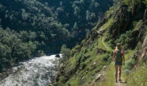
Historically significant to both native peoples and European-Americans, the Hite Cove area was used by the Ahwahneechee people in winter and spring to avoid the harsh high-elevation snow, before returning to Yosemite Valley in summer. John Hite settled here in 1862 where he operated a gold mine for the next 17 years. The mine produced a total value of 3 million in today’s dollars. The trail follows the steep Merced River canyon offering spectacular views in crisp, cool winter air.
Merced River Trail

- Distance: 5.5 miles out & back
- Elevation gain: 482 feet
- Max elevation: 1,100 feet
- Difficulty: easy-moderate
Starting near the BLM-operated McCabe Flat Campground, the Merced River Trail follows the old Yosemite Valley Railroad line above and along the Wild & Scenic Merced River. The hike features the ever-present serenade of flowing water to compliment the azure winter skies. At trail’s end there’s a narrow spur that climbs to a seasonal waterfall, worth the effort if running. The Merced River Trail is dog-friendly (on leash) and great for kids
FAQS: Yosemite Winter hikes
YES. Winter hiking in Yosemite Mariposa is possible due to its varied topography and range of elevations. Of course it’s essential to check current weather conditions, but the abundance of trails in the 1,000 to 5,000 foot range make for invigorating walkabouts surrounded by a striking palette of deep blues, bold greens and a dusting of white on the nearby peaks. Add to that the long shadows created by the low winter sun and the mood is set!
Waterproof boots, a warm base layer, a waterproof layer, and don’t forget the sunscreen! Also be sure to have a map, snacks, water and if you’re going somewhere where the trail may be icy, crampons or spikes are a must.
This answer depends on a few factors, most notably the weather and the elevation. Around Yosemite Valley there is at least a chance of encountering snow on the trails, but at higher elevations its almost a certainty that you’ll encounter some snow.
Check out the Yosemite Mariposa webcams for a live glimpse at current weather and snow conditions.
- May 14, 2026100 Things To Do In Mariposa County | Outside YosemiteDiscover 100 things to do in Mariposa County beyond Yosemite National Park, from outdoor adventures and historic Gold Rush towns to local food, lakes, art, and hidden gems throughout the Sierra foothills.Read More
- April 20, 2026Plan Your Next Corporate Gathering in Yosemite Mariposa CountyThere are many reasons to choose a conference venue in Yosemite Mariposa County for your next corporate meeting. If your group needs space to think clearly, connect meaningfully, and step […]Read More

- February 11, 2026Retreat-Style & Experiential Meeting Settings in Yosemite Mariposa CountyWhen meetings are designed for reflection, connection, and shared experience, the setting matters as much as the agenda. Yosemite Mariposa County offers retreat-style meeting environments where nature is not a […]Read More